top of page
January 3-13 2025
Ice trying to build along SW Michigan, snow from Winter Storm Cora


January 13-15 2025
Small Polar Vortex SW Michigan, wind chills down to 10°F
35+ mph wind gusts


January 18-24 2025
Large Polar Vortex SW Michigan, wind chills down to -20°F
-5°F Temp
50+ mph wind gusts


January 25-31 2025
sunny skies and people walking on Ice in SW Michigan

sunny skies in SW Michigan
February 1 2025
Double the Johns plowing through the ice in SW Michigan
Tug boat names: John Marshall (Cal River Fleeting) and John Henry (King Company)

February 3 2025
Kayaks next to Ice Lilly Pads Taken by Nates Dronography

February 5-6 2025
0.05-0.10" of ice in SW Michigan


February 16-17 2025
~1-3" of snow and strong wind in SW Michigan


February 20 2025

February 24-25 2025
Shifting Ice sheets & lilies as warmer temps come in SW Michigan


Reflection before the storms of March 2 2025

March 10-13 2025
Warm up before Massive Storm


March 14-16 2025
Thunderstorms, Dust Storm?, wind and Snow in SW Michigan & Midwest
St Patrick's Day Weekend


Dust Storm like Conditions
March 19-20 2025
Ominous Scud Cloud over Water Tower
Severe Weather, Dust, wind, 20+ft Waves & snow
in SW Michigan


Gales of March? Looks more like November


March 24-27 2025
10+ft waves crashing onshore to Fishing in SW Michigan


March 28 2025
Morning Thunderstorms in SW Michigan as the Warm Front comes in for the Large system


March 30 2025
50-80 mph wind Gusts, Possible Derecho and Rare Roll Cloud coming into SW Michigan, Produced 14 Tornadoes in one day
78 mph wind Gust in Benton Heights Michigan, windows blown out in Cass


Rare Roll Cloud coming over Saint Joseph Michigan


April 5-10 2025
Fiery sunset before the wind & snow


April 13-18 2025
Cold & Windy to Thunderstorms in SW Michigan


April 20-26 2025
Temp Swings in SW Michigan 4-9ft waves April 21 & 26
Temperatures between 34 and near 80 at times


Strongest Storm so far in Michigan 2025

May 1-5 2025
Rotating Thunder Storm (May 1) & Fiery Afterglow from Low Pressure System (May 5)


May 6-10 2025
Freighters in SW Michigan before the Pattern change


May 14-17 2025
Severe Weather & Dust Storm in SW Michigan causing 250,000+ without power between 1-4 Days
Unique First Dust Storm since 1930-1936 (Dust Bowl)


May 16 2025, Blowing Dust & Dust Storm SW Michigan


May 30- June 2 2025
Wildfire smoke coming down from Canada causing Hazy skies & smell


Large & Heavy Trees still down in SW Michigan from the May 15th storm (June 7 2025)


June 18 2025
Impressive Shelf Cloud coming over SW Michigan from dissipating storm


June 26-27 2025
Large Tornadic Waterspout & Hurricane Force wind offshore SW Michigan, also dropping 1.50-2.00" or more of Rain from the Multiple Storms


Path / Wind Speed of Tornadic Waterspout

July 4-17 2025
Quiet July in SW Michigan with a brief waterspout over Lake Michigan, with Fall like temps & 5-7ft waves


July 24 2025
Strong Storm over Lake Michigan producing likely Tornadic Waterspout, had wind gusts over 70 mph & hail over the lake before it came onshore in SW Michigan


July 26 2025
Union Michigan strange light, Transformer Exploding
July 31-August 4 2025
Colder Air & Wildfire smoke after ~1" of rain in SW Michigan


August 16-17 2025
Midwest & Great Lakes Severe Weather and Heavy Rain


August 19-20 2025
Waterspout close to shore off Saint Joseph Michigan
~0.20-0.60 Miles off shore


August 24-28 2025
Double Waterspout outbreak
Favorable Conditions for Waterspouts Southern Lake Michigan, Temp dropping into the 60s & 50s
-
5-8ft Waves on Lake Michigan
-
7-10ft Waves on Lake Michigan
Nearly 100 Waterspouts Reported across the Great Lakes


Near Record Dry Summer in the Mitten of Michigan from the Lack of Rain between 2-4 Months

September 4-6 2025
Strong Rainbow & 6-10ft waves in SW Michigan
Gales of September, Boat trying to go out


September 10-14 2025, America Reflects


September 21-28 2025, Drought & Thunderstorm


September 29 2025, Calumet SW Michigan Donuts

October 2025 Drought Conditions Persist in SW Michigan
Ongoing Drought in the Great Lakes is likely going to cause the Lake levels to drop over 3" in Erie, Huron and Michigan during November over 3.2 Trillion Gallons of water. Brief Wet Pattern likely this Fall & Winter causing there to be a higher chance for Severe Weather
3.2 Trillion Gallons = 4.8 Million Swimming Pools


October 19 2025 Wind Storm Produced 50+ mph wind gusts and 12+ft waves

October 23 2025 Large Rainbow and Lake Effect Rain showers


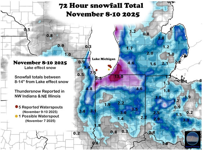
November 7-12 2025 Powerful Lake Effect snow in SW Michigan & NW Indiana
November 7 2025: Calm before the storm & Possible Brief Waterspout ~9:10pm


Possible Brief Waterspout


November 9-10 2025: 4 waterspouts off SW Michigan & 8+ft waves
The small waterspout recycled into a Larger Waterspout spotted by Beyond Chasing & Nates Dronography at Saint Joseph Michigan, 4 Waterspouts spotted


Surfer in front of waterspout off SW Michigan from Intense Lake Effect Snow Band


Large Drought in the Midwest & Great Lakes November-December 2025


November 26-27 2025
Powerful Thanksgiving Storm Producing 50-65+ mph Gusts & 25+ft waves with a Possible 40ft Rogue Wave that happened on Lake Michigan
Caused small plane to flip over at Benton Harbor Airport ~9:00am in the Morning


November 28-December 1 2025
Winter Storm Bellamy causing consistent bad weather to SW Michigan from the wind and cold, dropping over 12" of snow across the Midwest & Great Lakes
Causing Above Average snowfall across the area 500-750% Above Normal


December 4-7 2025
Ice, snow & Extreme Cold. wind chills making it down to -10-30°F on the morning of December 5th creating extreme amount of the steam
ongoing snow cover of 6-10" of snow with Locally 12"
Super Cold Moon Early December 5th 2025


Brightest Supermoon in 18 Years


December 13-15 2025
Lake Effect Snow & Extreme Cold wind chills creating Ice and Frost Quakes
Dropping Another 2-7" of snow in SW Michigan
5-10+ft waves on Lake Michigan


December 18-19 2025
From Rain & 50s to Extreme Cold & snow, wind chills made it down to -10°F with 40+ mph wind gusts
Rare Rainbow off SW Michigan
8-14+ft waves on Lake Michigan


December 21 2025
Fiery sunset as warmer temps come in
after the cold & snow, making the Ice shine like Crystals


December 24-25 2025
Ice balances in SW Michigan as it warms up from the Active Fall & Beginning of Winter


December 28-29 2025

2025 was a Unique year since we had the first Dust Storm since the 1930s and with Drought & Dry conditions during Summer with a lot of powerful storms during Fall & Winter


bottom of page