top of page
Super/Historic El Niño August 2026- June 2027

January 5-10 2026
Sunny skies before the warm air comes back in bringing the Temps back to 61.5°F on January 9th


January 14-16 2026
Morning Snow Squall in NE Illinois
Heavy Lake effect snow and wind,
Gusting 50-60 mph along Lake effect snow band
20" snowfall total in Northern Indiana


January 17 2026
Ice accumulating on the Lighthouse & pier as waves splash high into the sky, sun peaking out at times between snow showers


January 18-25 2026
Polar Vortex: Single Digit temps & -25°F wind chills
Heavy snow & wind, Aurora & Fox. Powerful wind and snow continues in SW Michigan
12-16+" snow cover from consistent snow
Feet of Ice on the Lighthouse & Beacon


Aurora & Fox before the storm


January 25-31 2026
4-10ft of Ice & snow Accumulation on the Lighthouse
Ice Castle from 4-10ft of Ice & snow encasing the lighthouse, 10ft of Ice weigh over 275 Pounds
Most Ice on the Lighthouse since Winter Storm Elliott & 2013/14 Winter


snow & Polar Vortex continuing into February


snow almost everyday of the Week making it close to Tying with 2013/2014 Winter Season
Causing Ice & snow to accumulate on the
Ice Castle/Monster & Pier


February 2-7 2026
Another 2-5" of snow in SW Michigan with over 570 Pounds of Ice still on the Lighthouse with the Ice on the Pier weighing between 1.5-2 Tons


Old Squaw & Goldeneye Ducks diving for small fish, February 4 2026

Black/White/3D of the Lighthouse & Pier
Feet of Ice accumulated = Over 480 Gallons of water

February 10-15 2026
3+ Weeks Covered Ice & snow creating reflections from the sun as the Ice Monsters start to melt


February 18-25 2026
Going from 63°F for Few Days to Cold, Windy & 4-8+" of snow SW Michigan & NW Indiana


Powerful Waves crashing into the pier from 40+ mph sustained wind
Narrow Band of 6-12" of snow & Powerful waves crashing onshore


March 6 2026
Michigan Mayhem Powerful Tornadoes Strike SW Michigan on Low Risk Day


March 13 2026
Powerful wind Hitting SW Michigan & Northern Indiana with 50+ mph sustained wind and 65+ mph wind gusts, Gusting over Hurricane Force at times


March 14-18 2026
Heavy snow and Cold returns to Michigan causing over 40" of snow in Upper Peninsula of Michigan with snow falling in SW Michigan that got hard hit by Powerful Tornadoes


March 30-April 5 2026
First Freighter in SW Michigan of the Year and Rounds of Incredible Lightning and chances for Severe Weather
100-130" of snow fell in SW Michigan during the Winter of 2025-2026


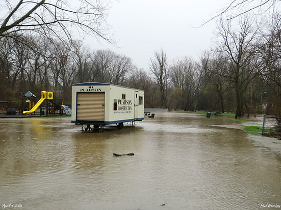
Thunderstorms & Severe Weather to Flash Flooding & Rising Rivers
-Saint Joseph River & Hickory Creek


April 13-21 2026
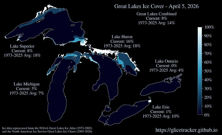
Record Snowmelt & Rainfall in Michigan causing Rivers and Streams to Rise across Michigan, Temperatures Reaching over 80°F then crashing into the 30s and 40s Bringing snow squalls to SW Michigan
Severe Weather on the 14/15 & 18th in SW Michigan
9 More Tornadoes in Michigan, Making the Total Tornadoes up to 14 in Michigan so far this year


Record Muskegon River Levels Newaygo Michigan, April 18-21 2026
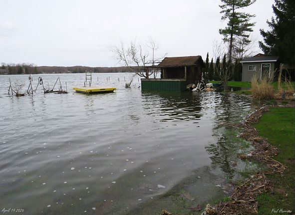
Very High Water Levels on Pickerel Lake, 3-4ft Higher than Normal


Earth Day Rotating Supercell off SW Michigan dropping 1.50" or Greater Hail, April 22 2026

April 27 2026
Powerful Wake Low Hitting West Michigan & NW Indiana with 40-70+ mph wind Gusts


Record Wet April 2026 for Michigan

April 29-May 7 2026
Cold start to may with Temperatures staying between 30-68 Degrees


May 18 2026
Possible Derecho Brought 50-90 mph wind Gusts to West, SW and Southern Michigan causing Damage and power outages across Michigan over 40,000 people lost power


June 10-11 2026
Derecho and Tornado Outbreak in the Midwest & Great Lakes causing Significant wind 60-90+ mph Gusts

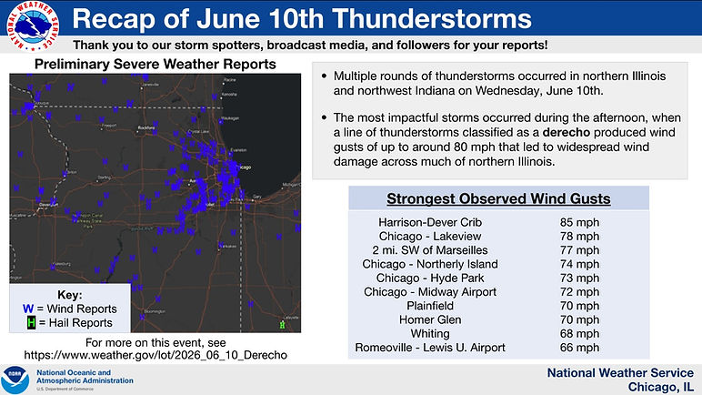

June 10 2026 Derecho Brought down Trees at Riverview Park in Saint Joseph Michigan from how strong the 50-60+ mph Gusts were


June 16 2026
SW Michigan Hail storm causing Hail to Accumulate on the ground like snow, 1/4" to 1.00" size in Bridgman Michigan


July 2-3 2026
Brief Waterspout & Powerful Derecho/Storm Strikes Southern Michigan causing 500,000+ to lose Power in Michigan, 60-80 mph wind Gusts as the storm plowed through the state


July 3 2026 Powerful Storm/Derecho


July 8 2026
Extremely Rare Glacial Rebound

Lake Michigan 2.9-3.0 M Earthquake, 2nd Earthquake in Lake Michigan since 2024 the only 2nd recorded one in 100 Years
Power of 9.3 Tons of TNT
600+ Reported Shaking in the area
38.91 gigajoules of energy, 84% of the yield of a MOAB
0.20 cm/s or 0.08 Inches

July 16-17 2026
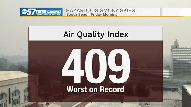
27 States covered in Wildfire smoke & Bad Air Quality
900-1,100+ AQI Levels over Michigan at times, Worst Air Quality in the World for Detroit Michigan for almost 2 Days
More Intense and worse than 2023
Eerie skies in SW Michigan this morning with Reddish/Pink sun Rising causing the sky to become Orange, July 16 2026
Causing people to stay Inside from how Intense it was from eyes burning and Intense smell, equivalent of smoking 6-17+ cigarettes in 24 Hours



how fast it Grew in a span of 24 Hours between July 13-14th effecting Indigenous People who live in Ontario Canada
Super El Niño 2026/27:
Predicting First Ever El Niño over 4°C with Global Effects, Hard to tell what the Severe Weather is going to be like in SW Michigan


August 2-3 2026
6-8ft waves with Water Temperatures into the 40s along SW Michigan, Feeling & Looks more like Fall than Summer


August 11 2026
Midwest & Great Lakes Derecho Creating 100-120 mph wind Gusts Causing Widespread Power Outages from the Powerful wind. killing 2 in Indiana one of Tree Falling on House and the other from House exploding. Derecho knocked out power to over 400,000 people
Extreme Tornado Warning Issued for Berrien County Michigan for Tornadoes & 100+ mph Gusts, causing people to seek shelter
Produced 3-6ft waves on Lake and Water Level Fluctuations, Producing Meteotsunami


Hardest Hit Areas Category 2 & 3 Force wind Gusts

Portage Indiana sign damaged from the Powerful wind

September 4-5 2026
SW Michigan Supercell bringing Dark Low Clouds & Shelf Cloud, Supercell had 40-50+ mph wind Gusts when it came into South Haven Michigan


September 13 2026
Super-Sonic 'Meteor"
SW Michigan Fireball/Meteor that Travel across the State in Milliseconds from the speed it was Travel went from over 150,000 mph to <40,000 mph when it crossed the State
Meteor was <2-4ft wide when it exploded over 158,000ft high


bottom of page